


CollineCanavesane app for iPhone and iPad
Developer: Laser S.r.l.
First release : 17 Jun 2015
App size: 20.97 Mb
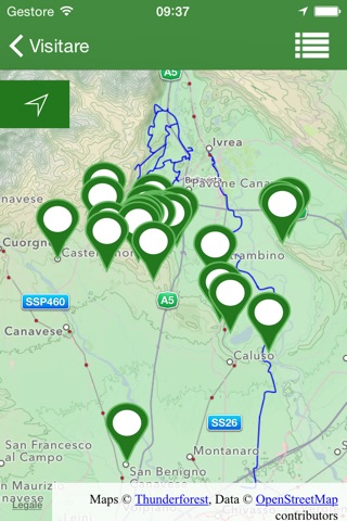
This application was created through an initiative of the Vialfrè Proloco (association promoting local culture and tourism), with the aim of promoting the town’s surrounding territory, and has been motivated by the many requests for informative material by people passing this way. We believe that the tourist value of the area is to be found first of all in its pathways through natural surroundings, which can be travelled on foot, by bicycle or on horseback and are accessible all the year round. Another attraction, as witnessed by the frequent passage of cyclists that are to be seen every day, is in the many surfaced cycle routes along secondary roads with little traffic, connecting our hills to the spectacular hollow of the Morainic Amphitheatre on one side and the East bank of the Orco torrent on the other. We have tried to acquaint you with this area and encourage you to visit it. In spite of being only a short distance from the big cities of the north west, it features an environment little changed by human activity. Its large spaces include wild woodland, wide flatlands surrounded by beautiful mountains, evocative lakes and ponds, areas of marsh and bog and charming hamlets which, if less important than some other sites in our Region, are nevertheless rich in history.
In making this effort, all on a voluntary basis, we have posed the problem of responsibility towards you, especially in the moment when we address a public that we do not know. While our environment has almost unspoilt, not greatly frequented areas, we do not believe that it poses excessive risks for those who venture there, because there are no particular hazards in the woods (e.g very thick vegetation, very steep slopes, cliffs, rock ledges and so on). We know however, especially for those coming from city surroundings, that moving in the natural environment without due caution can transform a pleasant trip into a situation of serious danger. The means at our disposal do not allow us to properly signpost all the routes; in fact if we did we would be taking away a good part of the charm of our territory. So we have also chosen to include unsignposted routes. However, you may not have access to this section of the application unless you have carefully read and accepted this text, which we have written to safeguard everyone, you and us, from improper and potentially dangerous use of the information given.
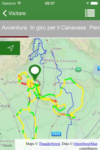
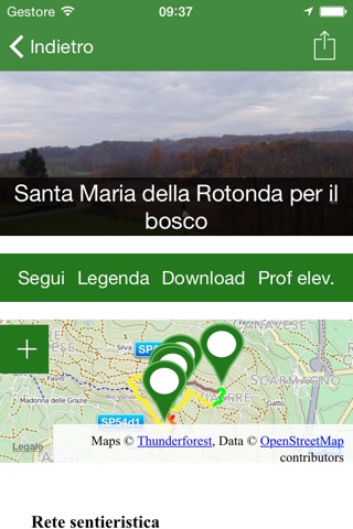
The route descriptions that we provide, except in a few particular, limited cases, have the sole purpose of giving you an idea of the itinerary and of providing data for length and height; they do not aim to guide you along the trail. Instead, for this purpose we give you the opportunity to download the route on your smartphone or tablet in GPX or KML format and to follow it using one of the many specialised applications that exist for this type of function. Within the Application we also give you a very simple function, “Follow”, which however we invite you to use, especially in the woods, only if you are familiar with tools of this kind and have adequate experience, equipment and training. We didn’t rank the routes by difficulty, because we think each one of us has different perception of it. We preferred to give you enough information to make your own decision, taking in account your personal level and you parameters.
We thought it would be useful to give you some information about events in the Canavese territory, with special focus and dedicated services for the events on the Vialfrè area.